Boishébert National Historic Site of Canada
Miramichi, New Brunswick
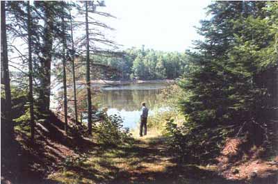
View between Wilsons Point and Beaubears Island
© Agence Parcs Canada / Parks Canada Agency, Ian Doull, 1999.
Address :
Highway 8, Northwest Bridge, Beaubears Island - Wilson's Point, Miramichi, New Brunswick
Recognition Statute:
Historic Sites and Monuments Act (R.S.C., 1985, c. H-4)
Designation Date:
1930-05-16
Dates:
-
1756 to 1759
(Construction)
-
1755 to 1760
(Significant)
Event, Person, Organization:
-
Charles Deschamps de Boishébert
(Person)
Other Name(s):
-
Boishébert
(Designation Name)
-
Beaubears Island
(Other Name)
-
Camp d'Espérance
(Other Name)
Research Report Number:
2001-040, 1985-017
DFRP Number:
04565 00
Plaque(s)
Original Plaque: Miramichi, New Brunswick
Following their expulsion from Nova Scotia in 1755, refugee Acadians came here to a settlement established by the Canadian officer, Charles Des Champs de Boishébert, from whom the island derives its name. Occupying the island opposite and the adjacent point, the settlement was a gathering area for expeditions against the English in Acadia and a point of transhipment for supplies from Quebec. Though the original settlement was destroyed by the English in 1760, Beaubears Island became during the 19th century the scene of substantial shipbuilding activity.
Original Plaque: Route 8, Miramichi, New Brunswick
The island opposite this point served as a concentration camp for refugee Acadians, 1756-1759. It was termed the "Le Camp d'Espérance", and was established by their protector, Charles Deschamps de Boishébert, a Canadian officer, after whom the island has been named.
Description of Historic Place
Boishébert National Historic Site of Canada is a wooded area with archaeological evidence of an 18th century Acadian refugee camp situated on Wilsons Point and Beaubears Island at the confluence of the Southwest and Northwest Miramichi River in New Brunswick. Official recognition refers to the area of Wilsons Point delineated at the time of designation.
Heritage Value
Boishébert was designated a National Historic Site of Canada in 1930 because: the Acadians, under the leadership of Charles Deschamps de Boishébert, had sought refuge on Wilsons Point from 1756 to 1760, and that Beaubears Island was an integral, functional component of this settlement which importantly relates the significance of the Acadian experience.
The heritage value of Boishébert lies in the landscapes which includes below-ground cultural resources of the settlement of refugee Acadians, historic viewplanes and a relatively undisturbed natural setting.
Source: Historic Sites and Monuments Board of Canada, Minutes, November 2001.
Character-Defining Elements
Elements which characterize the heritage value of this historic site include: the geographical location of Beaubears Island at the confluence of the Northwest and the Southwest Miramichi River, just downstream from Wilsons Point; viewplanes between Wilsons Point and Beaubears Island that are reminiscent of their shared history as an Acadian refuge and its supply and reconnaissance point; viewplanes from Beaubears Island downstream along the Miramichi River towards other areas of mid 18th-century Acadian settlement speaking to the accessibility and security of this place as a point of refuge; the integrity of a pathway that pre-dates 1840, extending the length of Beaubears Island approximately in its centre; the location and rare surface traces of occupancy on the mid 18th-century Acadian settlement site on Wilsons Point (Enclosure Park) including remnants of a cemetery and church site, smaller cleared areas and pathways within the wooded cover on the eastern extremity of the Wilsons Point opposite Beaubears Island; the integrity and materials of the surviving archaeological remains, features and artefacts in their original placement and extent representing tangible evidence of the activities, lifestyle and material culture of Acadian settlers, notably the rectangular house site, and remains of a communal fire hearth; the relatively undisturbed terrain of the meadow and wooded point at Wilsons Point; the relatively undisturbed biological diversity of the island.